Kappa Map Shaded Relief Map, Rolled, Texas
$19.95
Out of stock
Description
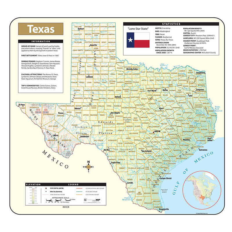
The Texas Shaded Relief Topographical Wall Map by Universal Map is full-color and laminated, making it durable, markable, and easy to read. Includes historical, anecdotal, and geographical information, an elevation scale measured in meters and feet, and a distance scale measured in miles and kilometers. Identifies county boundaries, state flag, motto, bird, flower, and tree, plus total area, population, and origin of name.
Additional information
| Weight | 1.50 lbs |
|---|---|
| Dimensions | 38.00 × 2.00 × 2.00 in |
You must be logged in to post a review.
Specifications
Unit of Measure: EachCountry of Origin: USA
Color: Multi
Material: Laminated Paper
Product Size: 28" x 38"
Package Contains: 1 - Shaded Relief Rolled Map
Package Count: 1
Battery Included: N
Barcode: 9780762582785
ISBN Manufacturer Reference: 9780762582785
HTS USCode: 4905990000
Related products
-
Evan-Moor Educational Publishers Daily Geography Practice Book, Grade 2
$29.99 Add to cart -

Replogle Globes Atlantis Globe, 12″
$107.56 Add to cart -
Teacher Created Resources Mysteries in History: Ancient History
$18.99 Add to cart -
Evan-Moor Educational Publishers Daily Geography Practice Book, Grade 1
$29.99 Add to cart


Reviews
There are no reviews yet.