ROYLCO INC. Dry Erase USA Map Class Pack R-59091
$14.99
Out of stock
Brand:
Roylco®
Description
Ages 6
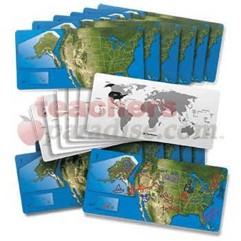
Gain a sense of the beauty of American geography! The United States is represented by a satellite view of the country with insets of Alaska and Hawaii to scale. We’ve drawn in each state. Use the maps to identify the States and their capitals. Draw landmarks and geographical formations! On the reverse side, take a look at the entire world and the position of the United States and it’s territories on the globe. Maps are 5 x 11″ (13 x 28 cm). Includes teacher guide. 24 American dry erase maps. by ROYLCO INC.
Related Products
The unpredictable events of a particular Tuesday unroll before the reader with the precision and clarity of a silent movie ...
No description available ...
The original Teddy Bear Counters will motivate children to learn about color, sorting, patterning, measurement, number sense and more. The ...
A clever device for converting the Stable and Non-Spill Water Pots into holders for brushes, pencils or pens. Available in ...
Using the same classic QuizmoT format: enough double-sided playing cards for the whole class to play, plastic markers, etc., kids ...
Best-selling Hot Dots is available in math word problem card sets! Each card includes several questions that guide students through ...
Christina, Grant, Mimi and Papa fly the Mystery Girl to Hershey, Pennsylvania just in time for the 100th anniversary of ...