ROYLCO INC. Dry Erase USA Map Class Pack R-59091
$14.99
Out of stock
Brand:
Roylco®
Description
Ages 6
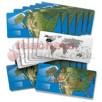
Gain a sense of the beauty of American geography! The United States is represented by a satellite view of the country with insets of Alaska and Hawaii to scale. We’ve drawn in each state. Use the maps to identify the States and their capitals. Draw landmarks and geographical formations! On the reverse side, take a look at the entire world and the position of the United States and it’s territories on the globe. Maps are 5 x 11″ (13 x 28 cm). Includes teacher guide. 24 American dry erase maps. by ROYLCO INC.
Related Products

New improved weighted base markers are 4"x 4"x18" long and are made of durable vinyl covered foam. No more springs ...
Build number fact fluency with magnetic manipulatives. Practice equations in a hands-on way--a more engaging method. Each tile measures 0.88" ...
Great for hollow blocks, unit blocks or toys. Accommodates a 340 piece set. Caster mounted. 20" wide x 36" long ...
Daily Paragraph Editing has everything for standards-based daily practice in language arts skills. Weekly lessons include a 4-paragraph composition for ...
No description available ...
These colorful calendar days are both decorative and educational. Each set of 36 has a repeating pattern as well as ...
Sprinkle a small amount of iron filings onto paper and move a magnet underneath to illustrate the pole patterns of ...